Western Alaska Minerals Reports Final 2021 Drill Results And Provides A New District Geological Interpretation At Its Illinois Creek Project, Alaska
Mar 29, 2022
![]()
TUCSON, ARIZONA, US – March 29, 2022 - Western Alaska Minerals (the "Company" or "WAM") (TSXV: “WAM”) is pleased to announce its final 2021 drill results and provide an update on the re-interpretation and new targeting at its 100% owned Illinois Creek property in western Alaska.
The 2021 drill program tested four different target areas across the Illinois Creek property highlighted by bonanza grade Ag-Zn-Pb CRD (carbonate replacement deposit) mineralization intersected at Waterpump Creek which has become a primary focus for 2022. Additional results are reported for vein hosted gold mineralization at the Honker prospect and oxide-gold targets near the Illinois Creek open pit.
Highlights
- Re-interpretation of the Illinois Creek property now shows fold-thrust belt geometries that define a series of stacked CRD manto targets along the >6-kilometer distance between Waterpump Creek and the Central Illinois Creek pit. Fold-thrust belts are a critical metallogenic control for the major CRD belts of the world, and this new interpretation highlights the tremendous potential of the target-rich Illinois Creek property.
- Drilling at Waterpump Creek in 2021 intersected significant oxide and sulfide mineralization highlighted by 9.1 m true thickness of high-grade sulfide mineralization grading 522 g/t Ag, 22.5% Zn and 14.5 % Pb in hole WPC21-09 and 15.6 m true thickness high-grade oxide mineralization grading 256 g/t Ag, 6.4% Pb and 0.7% Zn in hole WPC21-02 (previously reported). The new geological interpretation indicates potential for the project to host multiple CRD deposits like Waterpump Creek.
- Drilling on the Honker vein system intersected 7.6 m true thickness grading 2.42 g/t Au, including: 1.1 m @ 3.98 g/t Au, 1.3 m @ 4.45 g/t Au, 1.1 m @ 5.33 g/t Au (drill hole HK21-06)
- Initial exploration drilling south of the Central Illinois Creek pit, encountered broad zones of shallow oxide mineralization with anomalous Au, Ag, Cu, Pb, Zn (up to 40 meters thick). Individual sample intervals assay up to 2.16 g/t Au. New soil sampling has expanded this target area 1200 meters to the south and up to 400 meters in width. A deep gravity low and geochemistry suggest vectoring to a possible porphyry source in this direction.
- The 2022 exploration season will begin mobilizing the first week of April. Two C-130 Hercules flights to provide drill and camp expansion materials are planned in mid April. A +6,000 m drill program is anticipated to re-start in mid May and continue through early September. The program is expandable based on success thru mid-October. The focus will be on step out drilling of the WPC sulfide mineralization to gauge the overall footprint of the bonanza mineralization encountered in 2021.
Kit Marrs, Western Alaska Minerals CEO commented, “The Company had a very successful 2021 drilling program. Three targets at Waterpump Creek, Illinois Creek oxide gold and the Honker gold vein system were tested for the first time since 1984. Drill hole WPC21-09 was an extraordinary drill intercept and has transformed the company. We now have both excellent precious metal and polymetallic base metal potential. The intercept of 9.1 meters true thickness grading 522 g/t Ag, 22.5% Zn and 14.5 % Pb is one of the best drill intercepts in the silver space over the past few years.
Going forward, this year’s drill program will focus on the sulfide CRD potential now apparent on the Illinois Creek property and include defining a resource at Waterpump Creek and exploring the high-grade potential at Last Hurrah. Our two company owned drill rigs are on-site and ready to start drilling in mid-May. The plan is to complete a minimum 6,000-meter drill program. If the early drilling is successful, we will add to the drill budget as warranted.”
_____________________________________________________________________________
WAM’s 2021 drill season at the Illinois Creek property focused on a series of underexplored historical target areas:
1) the Waterpump Creek Ag-Zn-Pb CRD deposit (Carbonate Replacement deposit),
2) the Honker intermediate sulfidation Au vein swarm,
3) potential extensions to the Illinois Creek oxide Au-Ag-Cu deposit and,
4) the Ag-Zn-Pb Last Hurrah CRD prospect.
In addition to the widely targeted 2021 exploration drilling, a major soil sampling program was completed and was utilized along with the extensive historical geophysical surveys to reinterpret the Illinois Creek property and district as part of the northwestern Alaska mid Jurassic fold-thrust belt.
Waterpump Creek – 2021 Drill Results
Results from the Waterpump Creek deposit have been released in two previous news releases dated November 15, 2021, and January 18, 2022, and are shown in Table 1.
Table 1. 2021 Waterpump Drill Results
| Drill hole | From (meters) |
To (meters) |
Thickness (meters) |
No Recovery (meters) |
True Thickness (meters) |
Ag g/t |
Pb % |
Zn % |
Ag Eq g/t* |
| WPC21-01 | 21.5 | 32.4 | 7.4 | 3.1 | 7.4 | 20 | 0.4 | 2.5 | 134 |
| WPC21-02 | 23.2 | 39.9 | 16.7 | 15.7 | 256 | 6.4 | 0.7 | 484 | |
| including | 23.2 | 26.2 | 3 | 2.8 | 1094 | 27.4 | 0.3 | 1960 | |
| 36.9 | 39.9 | 3 | 2.8 | 287 | 2.1 | 2.8 | 466 | ||
| WPC21-03 | 50.9 | 52.4 | 1.5 | 1.4 | 1337 | nil | nil | 1337 | |
| 63.1 | 75.6 | 9.7 | 2.8 | 9.1 | 89 | 7.7 | 6.3 | 584 | |
| WPC21-04 | 64.9 | 71.2 | 6.3 | 5.9 | 76 | nil | 5.2 | 283 | |
| including | 64.9 | 66.4 | 1.5 | 1.4 | 315 | nil | 0.5 | 335 | |
| WPC21-05 | 35.6 | 50.9 | 11.9 | 3.4 | 11.2 | 149 | nil | 2 | 230 |
| including | 35.6 | 39 | 3.4 | 3.2 | 507 | nil | 0.4 | 523 | |
| WPC21-06 | 119.7 | 122.8 | 3.1 | 2.9 | 8 | 0.4 | 2.5 | 122 | |
| WPC21-07 | FW | ||||||||
| WPC21-08 | Lost HW | ||||||||
| WPC21-09 | 109.4 | 120.9 | 10.5 | 1.0 | 9.1 | 522 | 14.5 | 22.5 | 1886 |
* Ag Equivalencies based on spot prices of $22/oz Ag, $1.00/lb Pb, and $1.30/lb Zn
A total of nine drill holes totaling 851 meters have been completed at Waterpump Creek targeting both shallow high-grade oxide mineralization and deeper high-grade sulfide mineralization culminating in the bonanza sulfide intercept encountered in drill hole WPC21-09. WPC21-09 lies downdip and along strike of four historical sulfide intercepts drilled by Anaconda (1984) and NovaGold (2005) and are summarized in Table 2.
Table 2. Historic Sulfide Intercepts Waterpump Creek
| Drill hole | From (meters) |
To (meters) |
Thickness (meters) |
True Thickness (meters) |
Ag g/t |
Pb % |
Zn % |
Ag Eq g/t* |
| WPC84-027 | 107.3 | 115.1 | 7.8 | 6.8 | 771 | 9.8 | 10.5 | 1402 |
| WPC84-031 | 124.4 | 135.0 | 10.6 | 9.2 | 289 | 10.1 | 12.1 | 979 |
| WPC84-038 | 145.1 | 153.6 | 8.5 | 6.8 | 170 | 6.0 | 15.3 | 832 |
| KH05-02 | 102.4 | 110.0 | 7.6 | 6.6 | 608 | 18.4 | 27.3 | 2029 |
High-grade sulfide mineralization encountered in WPC21-09 and the historical Anaconda and NovaGold drilling is open down dip and to the north and south. Additional drilling is highly anticipated in 2022.
Honker – 2021 Drill Results
Honker is an intermediate sulfidation vein swarm that lies 10 kilometers (6 miles) NNW from the Illinois Creek pit. Exceptional Au surface sampling (numerous channel and chip samples >15 g/t Au) over 800 to 900 m of strike length along with a few historical drill tests by Anaconda in the 1980s, suggested an opportunity to develop a high-grade gold resource.
WAM drilled 6 shallow NQ drill holes totalling 636.3 meters in an initial test of the vein system. No historical core from the 1982 Anaconda drilling has been preserved. Table 3 summarizes both 2021 WAM drill holes and 1982 Anaconda drill holes.
Table 3. 2021 Honker Drill Results
| Drill Hole | From (meters) |
To (meters) |
Thickness (meters) |
True Thickness (meters) |
Au g/t |
Ag g/t |
| 2021 Drilling | ||||||
| HK21-01 | 27.0 | 28.2 | 1.2 | 0.7 | nil | nil |
| HK21-02 | 40.9 | 41.4 | 0.5 | 0.2 | nil | nil |
| HK21-03 | 32.7 | 33.4 | 0.7 | 0.5 | nil | nil |
| HK21-04 | 12.8 | 15.7 | 2.9 | 2.2 | 1.56 | 5.5 |
| HK21-05 | 58.9 | 63.4 | 4.5 | 2.6 | nil | nil |
| HK21-05 | 74.2 | 75.4 | 1.2 | 0.7 | nil | nil |
| HK21-06 | 70.1 | 84.1 | 14.0 | 7.6 | 2.42 | 6.8 |
| Including | 70.1 | 72.2 | 2.1 | 1.1 | 3.98 | 21.3 |
| including | 77.7 | 80.1 | 2.4 | 1.3 | 4.45 | 6.7 |
| including | 82.0 | 84.1 | 2.1 | 1.1 | 5.33 | 9.7 |
| 1982 Drilling | ||||||
| HK-3 | 33.6 | 35.3 | 1.7 | 0.9 | 5.14 | 4.1 |
| HK-3 | 56.2 | 57.0 | 0.8 | 0.4 | 3.57 | 8.9 |
| HK-4 | 46.9 | 50.8 | 3.9 | 1.6 | 8.68 | 17.2 |
| including | 46.9 | 48.0 | 1.1 | 0.4 | 22.50 | 47.3 |
| including | 47.5 | 48.0 | 0.5 | 0.2 | 38.39 | 79.9 |
| HK-9 | 11.3 | 12.5 | 1.2 | 0.7 | nil | 43.9 |
| HK-9 | 61.1 | 63.1 | 2 | 1.1 | nil | 6.5 |
| HK-10 | 8.5 | 13.4 | 4.9 | 3.6 | 3.61 | 7.1 |
| including | 8.5 | 9.0 | 0.5 | 0.4 | 11.52 | 22.6 |
Drill results show the top part of a high-level intermediate sulfidation vein system with grade improving to the north and down dip. Figure 1 is a long section of Honker main vein showing drill pierce points, vein thickness and Au grades.
Figure 1. Long section of Honker Main vein
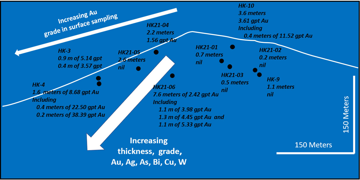
Approximately 300 meters of the 900-meter strike length of the vein has been tested to a depth of approximately 75 meters. Both grade and thickness increase to depth and along strike to the north. H21-06 cut a 7.6-meter vein with numerous 1+ meters splays grading from 3 to 5 g/t Au. Slightly to the north historical Anaconda drill hole HK-4 cut 1.6 meters of 8.68 g/t Au including 0.2 meters of 38.39 g/t Au. Importantly, Ag, As, Bi, Cu and W increase dramatically to the north and down dip with intervals up to 0.45% Cu, >10000 ppm As, 4619 ppm Bi, and 115 ppm W. Trace amounts of tennantite, arsenopyrite, and native gold were recognized in oxidized ferruginous and scorodite-stained vein silica. Significant additional drilling is warranted.
Illinois Creek South and East Extensions – 2021 Drill Results
Two scissored drill holes, IC21-07 and IC21-08, totalling 327 meters, were drilled approximately 150 meters south of the Illinois Creek pit targeting a major developing coincident Au, Cu, Pb, As soil anomaly. Though the drill holes did not encounter oxide ore grade intervals, they did cut broad zones of anomalous mineralization. IC21-07 cut strongly anomalous Au, As, Ag, Cu, Pb and Zn from the bedrock at 13.7 meters to 51.8 meters in locally gossanous and Fe-strained quartzite. Individual sample intervals reach as high as 2.16 g/t Au. Both drill holes encountered gossan at roughly 100 meters depth at or near the contact between quartzite and dolomitic quartzite. These gossan intervals, respectively 4.5 and 10.5 meters in width, are highly anomalous in Au, Ag, As, Sb, W, and Zn and could represent the farthest west expression of the East IC manto.
Expanded soil sampling south of IC21-07 and IC21-08 now shows the anomalous chemistry extending over 1.2 kilometers further to the south and varying from 200 to 400 meters in width. Historical gravity data show a deep underlying low which could present a potential porphyry target driving the system. This represents a major new untested target on the Illinois Creek property with significant exploration potential. The anomaly remains open under deep cover to the south into the Little Mud River valley. Planned 2022 CSAMT geophysics will help to target this exciting new anomaly.
Six drill holes totalling 425.6 meters were drilled along the perceived eastern extension of the Illinois Creek syn-mineral fault structure, host for the existing 525,000 oz AuEq resource (See February 2021 43-101 technical resource report). Drilling encountered severe sanding of the quartzites and dolomitic quartzites resulting in shallow inadequate tests of the targeted soil anomaly. Several of the East IC holes cut the East Illinois Creek manto but did not intersect the Au-Cu enriched Illinois Creek fault, the target of the drilling. Stratigraphic markers and apparent offsets suggest that the higher-grade Illinois Creek structure is offset and hidden below the East IC manto slightly south of the 2022 drill tests. Some drill profiles are warranted to locate and to begin to develop oxide resources east of the current resources outlined in the February 43-101 technical report on Illinois Creek oxide resources.
Importantly, the 2021 Illinois Creek extension drilling has recognized that the primary stratigraphic control on the immense East Illinois Creek manto/gossan is the contact between a roughly 100-meter-thick quartzite unit and underlying dolomitic quartzites.
Metals zoning in the syn-mineral structures show very elevated Au, Cu, and As chemistries zoned to the south and west of the Central pit at Illinois Creek and strongly support our contention that the porphyry generating the fluid package lies in that direction.
From a CRD perspective, these stratigraphic observations suggest that the untested out-cropping gossans at Gossan Hill and Macho Grande might represent new manto targets at the quartzite/dolomitic quartzite contact which hosts the East IC manto. These gossans which occur respectively 400 and 2000 meters to the northwest of the west pit beyond current limits of drilling might represent a major new trend of CRD mineralization. The Gossan Hill occurrence has some notable soil values up to 864 ppb Au and 5.4 g/t Ag.
Last Hurrah - 2021 Drill Results
Historical drilling in the Last Hurrah area targeted on extensive Ag, Pb, and Zn soil values in the footwall of the Waterpump Creek fault encountered numerous thin gossan zones often with fugitive manganiferous calcite as an indicator to nearby mineralization. The best historical intervals at Last Hurrah include 8 meters of 22 g/t Ag, 2.6% Pb and 6.0% Zn and 6 meters of 17 g/t Ag, 2.9% Pb and 8.2% Zn, both in KH06-10. As yet, no drill tests have been completed on the hanging-wall side of Waterpump Creek fault that will test the chargeability (IP) and resistivity anomaly in the 2005 IP survey undertaken by NovaGold.
LH21-01 drilled this year to test that geophysical anomaly, deviated down the footwall side of the fault and did not intersect the projected structure. Drill core showed numerous thin gossan zones, fugitive calcite and further defined the marble thrust plate which overlies manto-form mineralization at Last Hurrah. A 120-meter fluid package characterized by anomalous Pb and minor As, Zn and Ag has been recognized below the overlying marble thrust plate adjacent to the Waterpump Creek fault.
LH21-02 was subsequently collared 250 meters east of LH21-01 and drilled steeply west to approximately 200 meters depth. The drill hole was terminated in the overlying marble thrust plate due to adverse weather conditions in October but will be re-entered and completed as the initial test of the structure and IP/resistivity anomaly in 2022.
Illinois Creek District Re-Interpretation
Ongoing analysis of the often-confusing stratigraphic relationships in the Illinois Creek district has resulted in a complete re-interpretation of the district geology. The analysis included the extensive 2021 multi-element soil geochemistry survey, compilation, and further interpretation of historical aeromagnetic, gravity, EM and IP geophysical surveys and finally, re-logging of limited available core from the 2005-2006 NovaGold drill program along the Waterpump Creek/Last Hurrah trend.
The Illinois Creek district demonstrates an east verging fold-thrust belt comprised of a series of progressively deeper water facies thrust on the more continentally derived rocks to the west. This architecture results in a series of stacked thrust plates: deep water Triassic Angayuchum basalts (Plate 0); continental slope to deep water graphite and chlorite schists (Plate 1); carbonate platform dolomites (Plate 2); platform carbonates intruded by a major Jurassic greenstone sill (Plate 3); and continentally derived submarine quartzites and dolomitic quartzites (Plate 4).
Figure 2 is a preliminary geologic map of the Illinois Creek property and shows the development of major manto-form mineralization in part proxied by Pb soil values at or adjacent to three major syn-mineral structures, the Illinois Creek fault, the Waterpump Creek fault, and the 32E fault, and their intersection with a series of major thrust surfaces shown in blue on the map.
Figure 2. Preliminary Geologic Map of the Illinois Creek Property
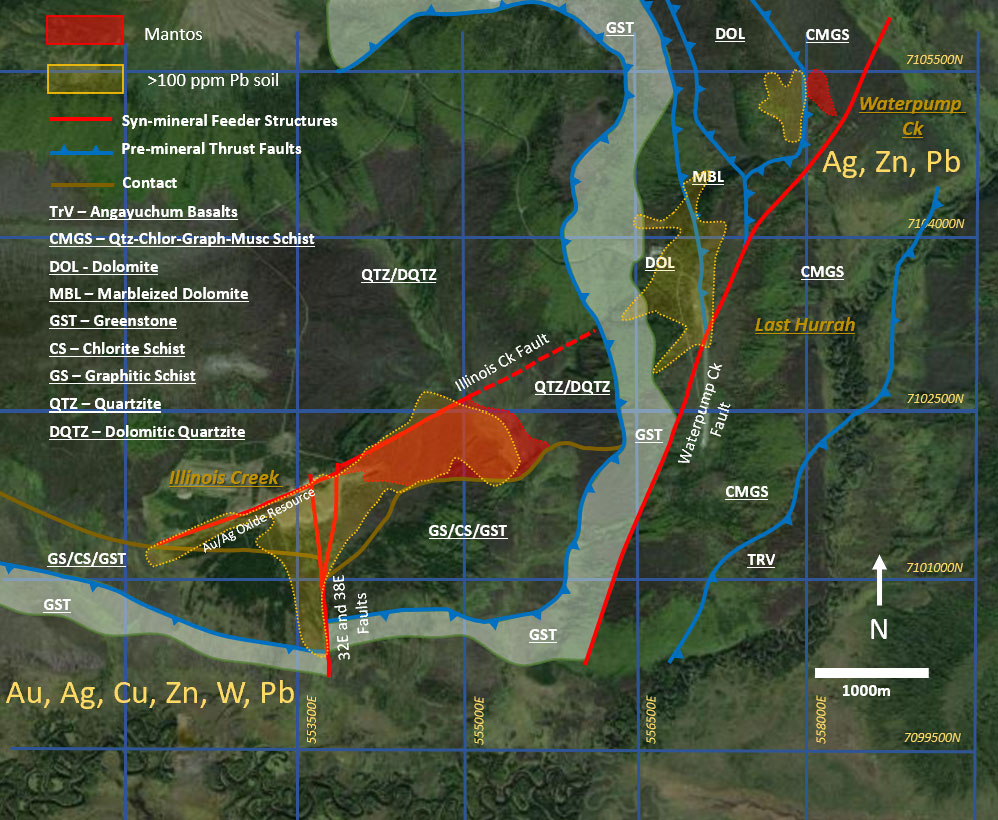
More specifically, carbonate replacement mineralization as mantos appear to have developed at or near the intersection of high angle syn-mineral structures and both thrust and stratigraphic contacts. Specific manto targets occur between 1) overlying chlorite muscovite graphitic schists (CMGS) and dolomite (DOL); 2) a dolomitic marble (MBL) and underlying dolomite (DOL); 3) a massive Triassic greenstone sill (GST) and underlying dolomitic quartzite (DQTZ), and 4) a major graphitic (GS) and chloritic schist (CS) package overlying a quartzite (QTZ) capping a major dolomitic quartzite (DQTZ). This quartzite/dolomitic quartzite contact is host for the very extensive East IC Manto.
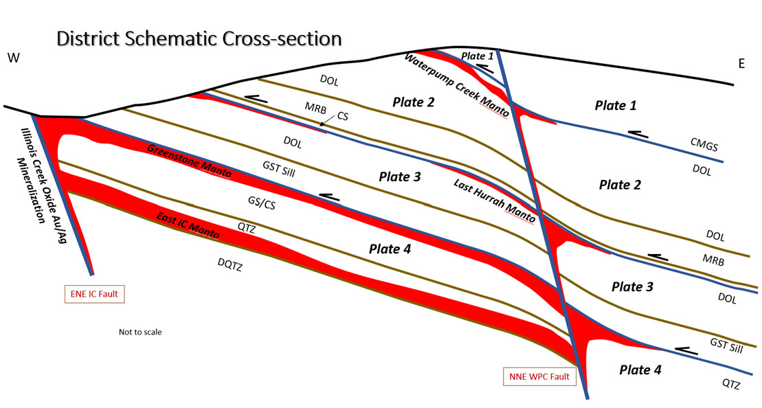
Significant potential for staked mantos exist along the entire 6-km strike length of the Waterpump Creek fault as well as under stratigraphic traps in and adjacent to the Illinois Creek and 32E faults. Figure 3 is a schematic cross-section of these evolving targets. In addition, recent extensive soil sampling and district-wide metal zonation patterns shown in Figure 2 suggests that the likely porphyry source driving the entire fluid system lies south and west of the Illinois Creek central pit.
Figure 3. District Schematic Cross-section - Potential Manto targets at Illinois Creek
2022 Plans and Timetable
As a result of the bonanza sulfide grades encountered at Waterpump Creek and the ongoing re-interpretation of the district geology, WAM has made a strategic shift focusing on the sulfide CRD potential now apparent on the Illinois Creek property versus the existing oxide Au/Ag resources. Exploration in the 2022 season is currently planning for two rigs drilling from mid-May through early Sept and expandable based on success thru mid-October. A minimum 6000+ meters is anticipated with 2/3 focused on immediate step-outs at Waterpump Creek to gauge the overall footprint of the bonanza mineralization.
The remaining drilling will focus on the Waterpump Ck/Last Hurrah/Illinois Creek CRD trend testing targets outlined in Figure 3 and 4 as discussed above. An extensive CSAMT/AMT survey by Zonge Inc. is planned in May/June to help with this exploration targeting.
Snow removal from the runway is currently planned to begin at the end of the first week of April. Two C-130 Hercules flights are scheduled in mid to late April before breakup to mobilize drill and camp expansion materials. Line cutting will be initiated in early May for the geophysical survey and drilling is expected to begin in mid May.
The qualified person who reviewed and approved the technical disclosure in this release is Stuart Morris, P. Geo., a qualified person as defined under NI43-101.
Quality Assurance/Quality Control of drill sample assay results have been independently monitored through a quality assurance/quality control (“QA/QC”) protocol which includes the insertion of blind standard reference materials, blanks, and duplicates at regular intervals.
Logging and sampling were completed at WAM’s core handling facilities located at the Illinois Creek mine camp in Alaska. Drill core was logged under an established procedure using Geospark commercial logging software, then diamond sawn on site. Half drill-core samples were securely transported to SGS Canada Inc. sample prep facilities in Whitehorse Yukon via air transport to Fairbanks, Alaska from Illinois creek and then commercial trucking to Whitehorse under a strict chain of custody protocol. Sample pulps were sent to SGS’s labs in Burnaby, Canada, for analysis. Gold content was determined by fire assay of a 30-gram charge with ICP finish. Silver, lead, copper, and zinc along with other elements were analyzed by ICP methods utilizing a four-acid digestion. Over-limit samples for silver, lead, copper, and zinc were determined by ore-grade analyses. SGS Canada Inc. is independent of Western Alaska Minerals and its affiliates.
SGS also performed its own internal QA/QC procedures to assure the accuracy and integrity of results. Parameters for SGS’ internal and WAM’ external blind quality control samples were acceptable for the samples analyzed. WAM is unaware of any drilling, sampling, recovery, or other factors that could materially affect the accuracy or reliability of the data referred to herein.
About WAM
WAM recently began trading as a Tier 1 company listed on the TSX-V and maintains corporate offices in Alaska and Arizona. WAM has reassembled and fully controls all claims in the historic Illinois Creek Mining district located in western Alaska near the Yukon River, covering 49,280 acres (77 square miles). This significant district was originally discovered by Anaconda Minerals Co. in the early 1980's. Since 2010, WAM and its private precursory company Western Alaska Copper & Gold Inc. (WAC&G) has been engaged in exploring and advancing its interests in the Illinois Creek mining district and now controls a diversified portfolio of five deposits that contain gold, silver, copper, lead, and zinc.
On behalf of the Company
“Kit Marrs”
Kit Marrs
President & CEO
For further information please contact:
Vanessa Bogaert, Director of Corporate Communications/IR at
vanessa@westernalaskaminerals.com
Or visit our website at: www.westernalaskaminerals.com
Forward Looking Information
Certain statements made, and information contained herein may constitute "forward looking information" and "forward looking statements" within the meaning of applicable Canadian and United States securities legislation. These statements and information are based on facts currently available to the Company and there is no assurance that actual results will meet management's expectations. Forward-looking statements and information may be identified by such terms as "anticipates", "believes", "targets", "estimates", "plans", "expects", "may", "will", "could" or "would". Forward-looking statements and information contained herein are based on certain factors and assumptions regarding, among other things, the estimation of mineral resources and reserves, the realization of resource and reserve estimates, metal prices, taxation, the estimation, timing and amount of future exploration and development, capital and operating costs, the availability of financing, the receipt of regulatory approvals, environmental risks, title disputes and other matters. While the Company considers its assumptions to be reasonable as of the date hereof, forward-looking statements and information are not guaranteeing of future performance and readers should not place undue importance on such statements as actual events and results may differ materially from those described herein. The Company does not undertake to update any forward-looking statements or information except as may be required by applicable securities laws.